Thanks for submitting!
You will be contacted as soon as possible


CLOSE

QUICK LINKS


PROFILES
PUBLICATIONS
EXPOSURE
VULNERABILTY
SOFTWARE
EQ MODELS
Search Results
1524 results found for ""
- Project locations world map | GEM Foundation
Close Completed Location Ongoing
- METEOR | Global Earthquake Model Foundation
Projects METEOR Modelling Exposure Through Earth Observation Routines (METEOR) Versión en español English version Share Facebook X (Twitter) LinkedIn Overview Outcomes Training Outreach Photos Publications Anchor 1 Background At present, there is a poor understanding of population exposure in some Official Development Assistance (ODA) countries, which causes major challenges when making Disaster Risk Management decisions. Modelling Exposure Through Earth Observation Routines (METEOR) takes a step-change in the application of Earth Observation exposure data by developing and delivering more accurate levels of population exposure to natural hazards. Providing new consistent data to governments, town planners and insurance providers will promote welfare and economic development in these countries and better enable them to respond to the hazards when they do occur. Objectives METEOR aims to formulate an innovative methodology of creating exposure data through the use of EO-based imagery to identify development patterns throughout a country. Stratified sampling technique harnessing traditional land use interpretation methods modified to characterise building patterns can be combined with EO and in-field building characteristics to capture the distribution of building types. These protocols and standards will be developed for broad application to ODA countries and will be tested and validated for both Nepal and Tanzania to assure they are fit-for-purpose. Objectives of the project look to: deliver exposure data for 47 of the least developed ODA countries, including Nepal and Tanzania; create hazard footprints for the specific countries; create open protocol; to develop critical exposure information from EO data; and capacity-building of local decision makers to apply data and assess hazard exposure. Collaborators METEOR Project Consortium The British Geological Survey (BGS) ImageCat National Society for Earthquake Technology (NSET) The Disaster Management Department-Tanzania The Humanitarian OpenStreetMap Team (HOT) Oxford Policy Management Limited (OPM) Fathom Location Nepal, Tanzania For more details on the METEOR Project, click read more below to visit the website. Anirudh and Nicole will be producing vulnerability data for different building types to different hazards for Nepal and Tanzania. About 20 project participants from GEM, Tanzania Prime Minister’s Office-Disaster Management Department (DMD), NSET, BGS, HOT OSM, ImageCat and OPM... Modelling Exposure Through Earth Observation Routines: EO-based Exposure, Nepal and Tanzania granted by the UK Space Agency Anirudh Rao and Nicole Paul participated in the quarterly UK Space Agency #METEOR Project meeting and workshops in Kathmandu, Nepal. To download the METEOR Project official deliverables documents, click the Read More button below.
- GEORGIA DRR | Global Earthquake Model Foundation
Projects GEORGIA DRR Capacity building to understand and take action on seismic risks in Georgia Versión en español English version Share Facebook X (Twitter) LinkedIn Overview Anchor 1 Background This project aims to enhance the understanding of earthquake impacts in Georgia and to address the following two challenges: i. The lack of understanding of potential earthquake risk and the impact on people, infrastructure and the economy at large; and ii. the lack of efforts to reduce the vulnerability of existing infrastructure, particularly critical emergency response infrastructure. The project is divided into 5 tasks, with the GEM Risk Team contributing to all tasks, with a specific emphasis on developing exposure models, identifying vulnerability models and running the probabilistic seismic risk assessment with the OpenQuake engine: Task 1 – Project Inception Task 2 – Preparation of Input Data & Development of Input Models Task 3 – Seismic Risk Analysis Task 4 – Recommendations on Risk Reduction Strategy Task 5 – Capacity Building Workshops Duration: 2020-2021 Objectives The objective of this project is to provide greater insight to the World Bank into the exposure of Georgia’s emergency response sectors to earthquakes and the potential consequences, as well as strategies to build seismic resilience in these sectors. The findings allow the World Bank to develop recommendations and better advise the Government of Georgia on how to: i. enhance its capacity to plan for future risk reduction investment programs based on a better understanding of earthquake risk in emergency response buildings; ii. develop options for a framework for a future short, medium and long-term intervention strategy; and iii. communicate and build consensus on earthquake risks and potential interventions in key sectors. Collaborators GEM Foundation, Arup, Progress Project LLC, Ilia State University Funding partner: World Bank Group Location Georgia
- PERU PUBLIC SCHOOLS | Global Earthquake Model Foundation
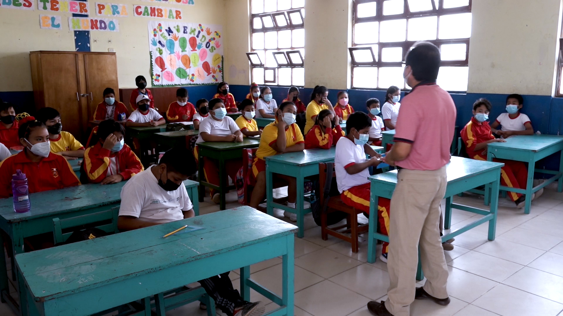
Projects PERU PUBLIC SCHOOLS Development of an Insurance Program for Peru’s Public Schools Versión en español English version Share Facebook X (Twitter) LinkedIn Overview Anchor 1 Background The project aims to protect more than 50,000 public schools in Peru against the impact of natural hazards, and to improve continuity for children’s education by accelerating reconstruction and strengthening the country’s resilience through an innovative insurance programme. The GEM Hazard and Risk Teams are contributing to the design of the insurance programme with expertise in the earthquake hazard and risk modelling of school buildings in Peru. For more information, visit https://www.bmz.de/en/issues/climate-change-and-development/climate-risk-insurance/59532-59532. Duration: 2020 - 2024 Objectives The main objective of this project is to design an insurance programme for Peru’s public schools. The project will provide the Government of Peru with options to cover all or a subset of its more than 50,000 public schools against the impact of natural hazards thus accelerating reconstruction, while also strengthening the country’s resilience. Collaborators GEM Foundation, AXA XL, Munich Re, Peruvian Association of Insurance Companies (APESEG), JBA Risk Management, InsurTech Picsure. Funding partner: Germany’s InsuResilience Solutions Fund (ISF) Location Peru
- SERA Project | Global Earthquake Model Foundation
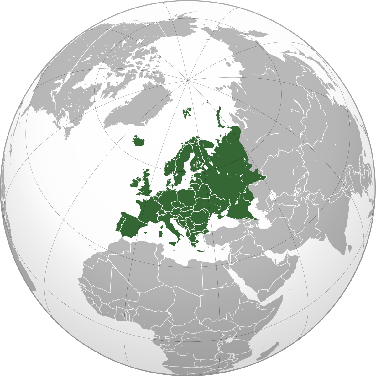
Projects SERA Project Seismology and Earthquake Engineering Research Infrastructure Alliance for Europe (SERA) Versión en español English version Share Facebook X (Twitter) LinkedIn Overview Anchor 1 Background The Seismology and Earthquake Engineering Research Infrastructure Alliance for Europe (SERA) aims to reduce the risk posed by natural and anthropogenic earthquakes based on innovative research and development projects. SERA will significantly improve the access to data, services and research infrastructures for scientists and other professionals. GEM's contributions focus on taxonomy and exposure of residential, commercial and industrial buildings in Europe; physical vulnerability assessment for buildings; integrated earthquake risk analysis using the risk assessment framework and OpenQuake software established by the Global Earthquake Model. SERA is a Horizon 2020-supported programme responding to the priorities identified in the topic INFRAIA-01-2016-2017 ‘Integrating Activities for Advanced Communities’. SERA involves 31 partners and 8 linked third parties in Europe. It started in May 2017 and will last for three years. Objectives The EUCENTRE-SERA project is collaborating closely with the GEM Foundation (Global Earthquake Model) to: develop a European Risk Modelling framework that brings together the strengths of previous projects such as SHARE, NERA and fills in the research gaps; integrate knowledge and data from other SERA working packages; and build on the risk assessment framework and software developed by GEM. SERA is engaging 31 partners from 16 European countries. They all have leading expertise in the operation of experimental facilities, monitoring infrastructures, and data repositories in the fields of seismology, anthropogenic hazards or earthquake engineering. (complete list ) Location Europe EM-SERA OpenQuake Training in Istanbul, Turkey SERA European Building Exposure Workshop: From European Hazard to Risk
- SOLOMON ISLANDS EXPOSURE | Global Earthquake Model Foundation
Projects SOLOMON ISLANDS EXPOSURE Assessing the Risk Exposure of Road Network to Climate and Natural Hazard Risks in Solomon Islands Versión en español English version Share Facebook X (Twitter) LinkedIn Overview Anchor 1 Background This project aims to conduct a robust multi-hazard risk assessment of the road network to climate and natural hazards in the Solomon Islands, both historically and under future climate projections. The project includes three main dimensions: - Characterization of the climate and natural hazards - Physical vulnerability of the road network - Multi-criteria criticality analysis The three main outputs are: - Multi-hazard maps - Road network risk exposure analysis (global risk score) - Identification of "first priority" road segments and estimation of their rehabilitation costs The GEM Hazard Team supports the project by computing seismic hazard maps and uses these to produce maps to classify low to high risks of earthquake hazards, according to their intensity and frequency. Duration: 2021 Objectives Many Small Island Developing States (SIDS) share a major common feature: they are among the most exposed nations to natural hazards and climate change. SIDS are also characterized by insularity and geographic remoteness, as well as small geographic area, economies, and population, all of which increase their social and economic vulnerability. This project aims to assist the Solomon Islands to better manage climate and disaster risks by improving the understanding of risk and the use of this information for risk reduction decision-making, and the design and implementation of investments at the provincial and community level. Collaborators GEM Foundation, ARIA Technologies, Actimar, Suez Consulting, Setec Group Funding partner: World Bank Group Location Solomon Islands
- HORUS | Global Earthquake Model Foundation
Projects HORUS Horus: Pilot for a generic damage evaluation methodology based on remote-sensing data Versión en español English version Share Facebook X (Twitter) LinkedIn Overview Anchor 1 Background Horus is a pilot project that explores the combination of high-resolution building inventory data from OpenStreetMap and other local sources with image-processing algorithms for the detection of earthquake damage and flood extents using remote-sensing data, along with supplementary geospatial datasets as inputs to a machine learning (ML) classification model. The ML model is trained using detailed building damage datasets from past events in a supervised learning framework, and the trained model is intended to be used to estimate the extent of damage and loss in events previously unseen by the model. The proposed framework is applied in three case study applications: March 2020 Mw5.3 Zagreb earthquake; January 2020 Mw6.4 Puerto Rico earthquake and August 2016 Louisiana floods. The GEM Risk Team is responsible for the overall coordination of the project involving multiple partners, compilation of building-level earthquake damage datasets, development of the ML models, and training and testing of the models. Duration: 2020 Objectives This pilot project, initiated and funded by the World Bank, aims to develop a framework for semi-automated damage and loss assessment due to earthquake and floods from Earth Observation (EO) data and other supplementary datasets, while also leveraging recent advances in machine-learning algorithms. These damage and loss estimates can potentially be used for transparent financial compensation and to target the distribution of resources geographically and temporally. Collaborators Advanced Rapid Imaging and Analysis (ARIA) team at the National Aeronautics and Space Administration’s (NASA) Jet Propulsion Laboratory (JPL) and California Institute of Technology (Caltech), the Global Earthquake Model (GEM) Foundation, JBA Risk, and the Humanitarian OpenStreetMap Team (HOT) Funding partner: World Bank Group Locations Earthquake case studies: Gorkha, Nepal; Puebla, Mexico; Puerto Rico, United States; Zagreb, Croatia Flood case study: Louisiana, United States
- Proyecto TREQ | Global Earthquake Model Foundation
Projects Proyecto TREQ Comunicación y Formación en la Evaluación de Riesgos por Terremotos (TREQ) Versión en español English version Share Facebook X (Twitter) LinkedIn Visión general Resultados Capacitación Comunicación Fotos Publicaciones Anchor 1 Resumen El Proyecto de Capacitación y Comunicación para la Evaluación de Riesgos de Terremotos (TREQ) fue diseñado para demostrar cómo la evaluación de la amenaza y el riesgo sísmico puede informar a los tomadores de decisiones en el desarrollo de políticas de reducción de riesgos, así como también cómo se puede comunicar adecuadamente el riesgo de terremotos a las partes interesadas y al público en general. [PDF Executive Summary English ] Objetivos El proyecto se organizó en dos partes principales. El primero tuvo como objetivo desarrollar la capacidad para la evaluación de la amenaza y el riesgo sísmico a nivel urbano en América Latina, Quito (Ecuador), Cali (Colombia) y Santiago de los Caballeros (República Dominicana); mientras que la segunda parte fue desarrollar material de capacitación, educación y comunicación para mejorar la comprensión del riesgo de terremotos en todo el mundo. El programa se diseñó para un amplio espectro de partes interesadas, categorizadas en cuatro grupos principales: gobierno(tomadores de decisiones/autoridades públicas), industria (practicantes y profesionales), academia (investigadores y profesores) y la comunidad. Ecuador Municipalidad de Quito Escuela Politécnica Nacional (EPN) Instituto Geofísico (IG) Colegio de Ingenieros Civiles de Pichincha (CICP) Pontificia Universidad Católica del Ecuador Dominican Republic Servicio Geológico Nacional (SGN) Oficina Nacional de Evaluación Sísmica y Vulnerabilidad de Infraestructuras y Edificaciones (ONESVIE) Comité Técnico Nacional (CTN) Pontificia Universidad Católica Madre y Maestra (PUCMM) Colombia Servicio Geológico Colombiano (SGC) Departamento Administrativo de Planeación Municipal (DAPM), Cali Unidad Nacional de Gestión del Riesgo de Desastres (UNGRD) Universidad EAFIT, Medellin Costa Rica Universidad de Costa Rica (UCR) Mexico Universidad Autónoma de Baja California (UABC) Ubicación Quito (Ecuador), Cali (Colombia) y Santiago de los Caballeros (República Dominicana) Evaluación del riesgo urbano en América Latina y el Caribe En este componente se generaron los siguientes entregables: evaluación de amenaza y riesgo sísmico a escala urbana para las tres ciudades TREQ: Quito (Ecuador), Cali (Colombia) y Santiago de los Caballeros (República Dominicana). Se desarrollaron modelos de vanguardia para cada ciudad en estrecha colaboración con socios locales. Los modelos de entrada y los resultados están disponibles en la siguiente dirección URL: [github.com/gem/treq-riesgo-urbano/ ] a. Informes de la ciudad Evaluación de Riesgo Sísmico para el Distrito Metropolitano de Quito [Español ] Evaluación de Riesgo Sísmico para Santiago de Cali [Español ] Evaluación de Riesgo Sísmico para Santiago de los Caballeros [Español ] b. Evaluación de peligros sísmicos Modelos probabilísticos de amenaza sísmica (PSHA) y conjuntos de datos para la evaluación de la amenaza a nivel urbano [PDF English ] Modelo Probabilístico de Amenaza Sísmica para la República Dominicana [PDF English | Español ] [Descargar Modelo ] Resultados de amenaza sísmica (condiciones en roca y en suelo [PDF English ] Análisis de la amenaza sísmica a escala urbana [PDF English ] c. Evaluación de Riesgo Sísmico Resumen ejecutivo sobre la evaluación del riesgo sísmico urbano para las ciudades de Quito, Cali y Santiago de los Caballeros [PDF English ] Tipologías constructivas en Quito, Cali and Santiago de los Caballeros [PDF Español ] Base de datos de exposición georreferenciada de población y edificios en cada ciudad de TREQ [Cali ] [Quito ] [Santiago ] Base de datos de funciones de fragilidad y vulnerabilidad para cada clase de edificio presente en el modelo de exposición [Datos ] Mapas y métricas de riesgo para cada ciudad [Cali ] [Quito ] [Santiago ] d. Escenarios de la ciudad Base de datos con rupturas seleccionadas para análisis de escenarios [Cali ] [Quito ] [Santiago ] Evaluación del escenarios de amenaza para sismos representativos en Quito, Cali y Santiago de los Caballeros [PDF English ] e. Aplicaciones Urbanas Deslizamientos y licuefacción inducidos por sismo en Cali [PDF English ] Mejora de la comprensión mundial sobre la amenaza y riesgo sísmico Esta parte del programa fue diseñada para mejorar la comprensión y el conocimiento de la amenaza y el riesgo sísmico, y para ayudar a cerrar la brecha entre la información producida en estudios detallados de amenaza y riesgo y su comunicación a una amplia variedad de partes interesadas (que van desde locales expertos con competencias para evaluar el riesgo sísmico, a los tomadores de decisiones responsables de la implementación de medidas de reducción del riesgo). a. Sitio web para la capacitación en línea de OpenQuake La capacitación en línea de OpenQuake se diseñó para diferentes tipos de audiencia con diversos antecedentes y experiencia. A través de esta plataforma, los participantes interactuaron con los equipos científicos y técnicos del GEM para conocer los principales conceptos de la evaluación del riesgo sísmico, así como las características básicas del software de OpenQuake. [English | Español ] b. Manual de OpenQuake en formato online El manual oficial se convirtió de látex al formato reStructuredText gracias al apoyo de @USAID. El nuevo manual está ahora en línea en formato HTML y se puede accederse en: [Webpage English ] c. Tutoriales en video sobre peligros sísmicos y análisis de riesgos usando OpenQuake El proyecto ha producido 15 videos de capacitación técnica utilizando el software de OpenQuake (en inglés y español), 7 videos con material para difundir los modelos y resultados de la evaluación del riesgo urbano en las ciudades TREQ y 2 videos para comunicar el riesgo sísmico al público en general. público. OQ Engine Video Tutorials [ English | Español ] d. Manual para realizar análisis de amenaza sísmica Este manual presenta los conceptos básicos de la metodología clásica de PSHA y el amplio espectro de alternativas para modelar la sismicidad y las incertidumbres (epistémicas y aleatorias) en el software de OpenQuake. La evaluación probabilística del peligro sísmico (PSHA) es la metodología principal para evaluar el peligro potencial que representan los terremotos. Los mapas de amenaza se utilizan ampliamente en los códigos sísmicos nacionales para la zonificación de la amenaza sísmica y las disposiciones de diseño estructural. [PDF English ] e. Capacitando a educadores TREQ ha colaborado con cinco profesores universitarios de América Latina para conceptualizar, crear e implementar un curso unificado para el estudio del riesgo sísmico a nivel universitario. Los folletos en inglés y español explican con más detalle el concepto detrás de esta iniciativa y describen los primeros resultados y experiencias de los profesores de Colombia, Costa Rica, El Salvador, Guatemala y México. [PDF English | Español ] Comunicación y sensibilización sobre terremotos Las actividades de este componente se centraron en sensibilizar al público sobre la amenaza y el riesgo sísmico mediante la capacitación de un grupo diverso de profesionales en reducción del riesgo de desastres (RRD), junto con el personal a cargo de comunicar los riesgos al público, y mediante la realización de talleres comunitarios en áreas seleccionadas de las ciudades piloto. Artículos de noticias Eventos El seminario web Comprensión del riesgo sísmico a través del desarrollo de capacidades y el intercambio de conocimientos atrae a cientos de participantes de todo el mundo. [Article ] [Event page English | Español ] [Video ] Presentación del modelo PSHA nacional para la República Dominicana: un seminario web conjunto organizado por el Servicio Geológico Nacional Dominicano en cooperación con GEM, Oficina Nacional de Evaluación Sísmica y Vulnerabilidad de Infraestructura y la Oficina de Asistencia Humanitaria de USAID. [Event flyer Español ] [Video English | Español ] ---- Artículos Raising Earthquake Risk Awareness: TREQ’s community workshops for the general public Urban hazard assessment of selected cities in Latin America Local solutions to global problems: reducing disaster risk through collaboration and openness TREQ Project Updates: Site Effects Modelling and Urban Exposure Models USGS has joined the TREQ initiative for urban earthquake scenarios TREQ capacity building: OQ online training updates Jan-Feb 2021 TREQ2020 – Capacity development and OpenQuake online training, year in review TREQ OpenQuake Online Training: Earthquake Scenarios - Ground Motion Fields Sept 2020 Más en la sección GEM News a. Material didáctico para sensibilizar a la comunidad sobre el riesgo sísmico: Aplicación para el área Metropolitana del Valle de Aburrá (AMVA) [PDF Español ] b. Video para comunicar el riesgo de terremoto al público en general [English | Español ] c. Guía para profesores para el desarrollo de un curso introductorio de riesgo sísmico [PDF Español ] d. Perfiles de respuesta y mitigación de riesgos urbanos para las ciudades TREQ [Cali ] [Quito ] [Santiago ] Boletin informativo El boletín del proyecto TREQ tiene la intención de compartir actividades en evaluación de riesgos urbanos y materiales de capacitación y educación sobre riesgos de terremotos con una amplia gama de partes interesadas locales de la academia, los sectores público y privado, así como la sociedad civil en América Latina,el Caribe, y más allá. Newsletter no. 3 - May 2021 Newsletter no. 2 - September 2020 Newsletter no. 1 - March 2020 Maiden issue [English ] Maiden issue [Españo ] BUSINESS NEWS Concientizando el Riesgo: talleres para el público en general 1/4 BUSINESS NEWS Inicio del proyecto de marzo de 2020 1/4 BUSINESS NEWS Fotos de la formación OpenQuake Online de noviembre de 2020 1/2 BUSINESS NEWS Reuniones en Quito 1/10 BUSINESS NEWS Reuniones en Guayaquil 1/1 Visión general TREQ Resumen Ejecutivo [English ] Evaluación de la amenaza sísmica Modelos probabilísticos de amenaza sísmica (PSHA) y conjuntos de datos para la evaluación de la amenaza a nivel urbano [English ] Modelo Probabilístico de Amenaza Sísmica para la República Dominicana [English | Español ] [Descargar Modelo ] Resultados de amenaza sísmica (condiciones en roca y en suelo [English ] Análisis de la amenaza sísmica a escala urbana [English ] Evaluación de Riesgo Sísmico Resumen ejecutivo sobre la evaluación del riesgo sísmico urbano para las ciudades de Quito, Cali y Santiago de los Caballeros [English ] Tipologías constructivas en Quito, Cali and Santiago de los Caballeros [Español ] Escenarios sísmicos Evaluación del escenarios de amenaza para sismos representativos en Quito, Cali y Santiago de los Caballeros [English ] Aplicaciones urbanas Deslizamientos y licuefacción inducidos por sismo en Cali [English ] Informes de la ciudad Evaluación de Riesgo Sísmico para el Distrito Metropolitano de Quito [Español ] Evaluación de Riesgo Sísmico para Santiago de Cali [Español ] Evaluación de Riesgo Sísmico para Santiago de los Caballeros [Español ] Formación y comunicación del riesgo sísmico Manual de capacitación sobre análisis probabilístico de riesgos sísmicos (PSHA) [English ] Material didáctico para sensibilizar a la comunidad sobre el riesgo sísmico. Aplicación para el área Metropolitana del Valle de Aburrá (AMVA) [Español ] Guía para profesores para el desarrollo de un curso introductorio de riesgo sísmico [Español ] Disclaimer The contents of this project website such as studies, reports, audio-visual, news articles, blogs, and other information or media products including those in the external links are made possible by the generous support of the American people through the United States Agency for International Development (USAID). The contents are the responsibility of the Global Earthquake Model (GEM) Foundation and do not necessarily reflect the views of USAID or the United States Government.
- AZERBAIJAN DRR | Global Earthquake Model Foundation
Projects AZERBAIJAN DRR Risk modeling and scenario analysis for Azerbaijan - Seismic risk analysis Versión en español English version Share Facebook X (Twitter) LinkedIn Overview Anchor 1 Background One of the analyses to be conducted under the World Bank Groups' Country Climate and Development Reports (CCDRs), is to look at the fiscal and economic impacts of disasters in Azerbaijan, including the size of the macro-fiscal risk posed by earthquakes, floods, and droughts, and identify potential opportunities to increase financial resilience. For the risk modeling and scenario analysis for Azerbaijan, the GEM Risk Team further expands the Azerbaijan model in GEM's Global Seismic Risk Model, by projecting the exposure and risk to 2050 by taking into account the evolving demographics and socio-economic conditions in Azerbaijan. Duration: 2022 Objectives The World Bank is preparing the Country Climate and Development Report for Azerbaijan. The CCDR aims to inform policy dialogue and engagement with the Government of Azerbaijan. This provides an opportunity to carry out several analytical pieces, including in the area of Disaster Risk Management, bringing together existing knowledge on the economic and social impacts of disasters and climate change, and delivering new analytical insights to support policy recommendations. Collaborators GEM Foundation Funding partner: World Bank Group Location Azerbaijan
- GEOINQUIRE | Global Earthquake Model Foundation
Projects GEOINQUIRE GeoINQUIRE: Geosphere INfrastructures for QUestions into Integrated REsearch Versión en español English version Share Facebook X (Twitter) LinkedIn Overview Anchor 1 Background The GeoINQUIRE project provides and enhances access to selected key data, products, and services, enabling the dynamic processes within the geosphere to be monitored and modelled at new levels of spatial and temporal detail and precision. Geo-INQUIRE benefits from a unique partnership of 51 partners consisting of major national research institutes, universities, national geological surveys, and European consortia. Geo-INQUIRE will enhance and make interoperable the activities of the involved partners and conduct dedicated training programs for their optimal use. A portfolio of 150 Virtual Access (VA) and Transnational Access (TA, both virtual and on-site) installations will be offered to the scientific community. The GEM Foundation is offering one of the Virtual Access services within the geohazard-and-multi-risk-assessment portfolio of services; this service will provide access to earthquake and secondary hazards impact data. More information: https://www.geo-inquire.eu/about/about-geo-inquire Duration: 2022 - 2026 Objectives The project aims to overcome cross-domain barriers, especially the land-sea-atmosphere environments, and will exploit innovative data management techniques, modelling and simulations methods, developments in AI and big data, and extend existing data infrastructures to disseminate these resources to the wider scientific community, including the EOSC landscape. Collaborators Please refer to: https://www.geo-inquire.eu/about/partners Funding partner: European Commission Location Potsdam, Germany